
This post covers my five-day tour of Lesotho. Unfortunately, I don’t have an easy means of drawing on the image above to show my route, but basically, I entered via Sani Pass, a rugged 4×4 route up the escarpment in the Drakensberg, which you can find on the map above on the east-central edge of the country. I then made my way to the village of Thaba-Tseka west of Sani, almost to the middle of the country. Then, I turned south and eventually made my way to Maletsunyane Falls, which is shown the map. Then I headed southwest to near Quthing, which you will also see on the map. Finally, I exited out of the country south of Quthing at a small border post called Telle Bridge, which is not shown on the map.
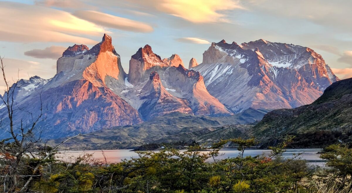
For this post, I decided to do a video slideshow of the countryside as I toured in the Green Dragon, but here are a few comments about the country to go with the video, without repeating what I already said about the country in my previous “Welcome to Lesotho” post. Even though the country is elevated high up on a geological plateau of sorts, there is nothing flat about this country. Indeed, everything is mountainous, with never-ending steep up and down slopes. I am not exaggerating when I say that I drove in second gear probably 75% of the time, either struggling to go up steep grades that were easily 20% at times – the damn Chinese and their road engineers – or trying not to use my brakes going down those same grades. I even had to go down to first gear at times. Rarely did I get into third gear, and I believe I got to forth gear maybe twice towards the end of the tour. The video just doesn’t do justice to the steepness of the country. And the roads don’t contour along the major drainages; rather, they go up and over the mountains at all times. Up-down, up-down, over and over. I must have driven over a dozen high passes along my route, and numorous minor ones. Fortunately, there were very few other vehicle on the roads, so I had the roads mostly to myself most of the time.
Next, there is hardly a tree to be found in the entire country. Well, that’s not quite true, but it felt like it. Most of the high elevation country, which is most of the country, has no trees at all; rather, it is all montain grassland and heathland as far as the eye can see covering all the mountain slopes, ridgetops and valley bottoms. Grass, grass, and more grass. You have never seen so much grass in mountain country, as opposed to grasslands on the flat prairies. The main occupation and land use is sheep and goat herding, with a few cattle thrown in occasionally. Also, keep in mind that it is winter and the dry season in these photos, so the vegetation is dry and brown mostly – but note the cherry blossoms on the few scattered planted trees.
Nest, geologically, most of the country is comprised of that igneous rock cap, mostly basalt, that I discussed previously in my Drakensberg video. If you pay attention in the video, you will notice the striking difference between the higher elevation igneous country with darker soils and rugged mountains covered with grass and heath, and without strong horizontal banding of the rocks. When I descend into a few of the lower elevation valleys, note the difference in the rock formations and soils. The rock formations are strongly bedded horizontally and the soils are reddish. These are obviously places where erosion has removed the basalt cap and eroded canyons out of the sedimentary rocks. This lower country looks a lot like places in northern Arizona and Utah.
If you want to take a drive through Lesotho, at least the part that I drove through, check out the following video slideshow. Note, the slideshow is in chronological order as I entered up through Sani Pass into Lesotho and the subsequent four days of driving cross country, sometimes on gravel (occasionally 4×4) and sometimes on nice paved roads – thanks to the Chinese I am told:
Lesotho video slideshow (11 minutes)
For the birders that might be following – you know who you are – there’s a not-so-great photo of a bird in flight. See if you can guess what this bird is. Hint, it is endemic to the Drakensberg and Endangered, and with the angle of the photo you can’t make out the tail, but it’s there. Don’t let the lack of a visible tail mislead you. Gold star if you guess the species.
New Species:
- Bearded vulture
- Cape rock thrush
- Southern bald ibis
The image of the raptor from below is a tough one, but I’ll make a wild guess: Booted eagle.
Sorry for sending this at such an awful time for you (night) but I wanted you to know I thought the history of Lesotho in the last blog was fascinating. Looks like you have the whole place to yourself now. We are at the airport in Jersey getting ready to board for JoBerg. Can’t wait to get there!! Long travel time. Thanks for all the great introduction to the flora and fauna. !!!
Thanks for the musical slide show. Enjoyed it! Looks a lot like our mid-west of the USA (Arizona, Nevada, parts of Colorado, Utah and Cal.)
Keep on trucking!!
Love Joan
Have to agree with Joan. Looks a lot like USA Southwest!
I agree with Brenda that your picture of the vulture/eagle/buzzard is a tough one. My guess is a Steppe Buzzard.
Lesotho looks interesting but obviously lacks much wildlife, being that you have no pictures of any. A few birds at least. Different southern Africa country definitely.
Did they build the roads for mining? Seems like there lacks much reason for them otherwise as low intensity grazing can’t pay for them.