After leaving Saadani National Park, Nancy and I headed south to the metropolis of Dar es Salaam, Tanzania’s largest city and economic hub located on the central coast. We spent two nights in Dar and then I headed south alone to the small coastal village of Kilwa:
Regarding Dar es Salaam, have you figured out yet that I don’t much like big cities – indeed most cities, large or small – but some are tolerable, such as Nairobi, but others are hell on Earth for me. Dar clearly falls into the latter category for me. It is total choas from the outskirts to the interior: an unorganized mass of humanity, exhaust-filled air, traffic congestion and patterns that quite frankly boggles the mind (i.e., there is no order to the traffic pattern, just chaos), and, as far we could tell, no redeeming attractions to compensate for the above. The video below has a couple minutes footage of me driving in the tuk-tuk and bus-filled streets of Dar as I was leaving the city on my own, but this was only a moderately chaotic scene as I could not video while driving in the truly chaotic scenes. No polyanna attitude on this one (sorry Sherry).
We stayed in a hotel in the downtown section of Dar which may have contributed to my opinion, as I expect there are some nice sections on the waterfront. We took care of some important shopping business on the way into the city and then chose to chill in the hotel for the next full day. Nancy got a pedicure and a massage while I used the fitness center, and we both caught up on some Netflix episodes. The following day, I left the city alone without my foremost partner and companion, Nancy, as she went to the airport for the long journey home. Sad day for both of us!
Driving south down the coast, I had no particular destination in mind. I simply wanted to get far enough south so as to get to my coastal destination the next day. I found a place on iOverlander and checked it out online and it looked great. It was a small beachside lodge and campsite outside the small coastal village of Kilwa about 6 hours drive south of Dar. Just before the turn off I pulled off to the side of the road to have a snack and turned off the engine. When I finished and got back into the Green Dragon and turned the key, I heard clicking and saw lights blinking on the dash, but no engine start – SHIT! It was clearly an electrical problem, not mechanical. I checked the batteries and filed down all the wire leads connected to both the primary and secondary battery. Nothing doing. The primary battery voltage was down a bit so that seemed like the most likely culprit. Anyways, some workers walked by and one of them spoke some very limited English and I had him phone the village ahead and have an auto electrician/mechanic come out and help. He came on a motorbike after an hour or so and checked all the wires and battery connections as I did, and tested all the fuses (there are many of the them in probably 4 or 5 different locations) and then speculated that the primary battery was bad. I was suspicious of the diagnosis at firest because it had been fine all along showing no signs of failing. So, he went back to town and an hour later came back with a couple of spare batteries. After messing around a bit, we started the Green Dragon with one of his spares and put the original back in, drove to the village, turned off the engine and tried to start it again, but it failed completely. This confirmed that the battery had simply failed – argh! So, I purchased the best new battery available, hoping that it will prove to be a decent battery, and went on my merry way about 5-6 hours after stopping for my snack.
That’s the bad news of the day; here’s the good news. The Kilwa Beach Lodge was another hidden gem. I was the only guest and I parked the Green Dragon under palms facing the beach, tidal flats and breakers on the offshore reef. Cool offshore breeze, waves gently rolling in, and a nearly full moon made for yet another sublime tropical beachside campsite. Unfortunately, I only had the evening to enjoy the site due to my battery delay. Here’s a couple of photos but there is also footage in the video below:
Kilwa beachside campsiteSunrisse from my Kilwa beachside campsite
Here’s a very short composite video that contains two snippets: one of driving in Dar and another of my Kilwa beachside campsite:
We left the Usambara Mountains and headed back to the coast to Saadani National Park.
We took a different way back than the way we came (up that steep escarpment if you recall) and it was an absolutely delightful and spectacular drive. The road was packed dirt, perfectly graded, and smooth driving – so nice when you encounter these roads unexpectedly. The road wound through the mountains, climbing and descending hillsides carved up into small farms with perfectly terraced gardens and traversing valley bottoms with rice patties and vegetable crops covering the floodplains. Everything was green and lush and so colorful. Often the backdrop included rugged mountain slopes with rocky outcrops. Unfortuntely, we were too mesmerized by the scenery and keeping an eye on the winding road with lots of blind corners to take any pictures or videos, so you will have to use your imagination.
Saadani National Park, encompassing 410 square miles, was officially declared a National Park in 2005 from the former Saadani game reserve. Saadani has been one of the most heavily contested Parks in Tanzania since the National Parks Authority designated the Park. Most of the local communities surrounding the Park, and formerly residing inside the Park, have fought the Parks Authority over the declaration and continue to dispute the authority of the government to declare the area as a National Park. However, apparently once the area was designated an official Park, the wildlife populations began to recover from overharvesting by both the big game hunters and poaching. Indeed, few visitors go to Saadani to see the wildlife, but rather to enjoy the miles of beaches and undeveloped coastline. Any wildlife observations are considered a bonus. As expected, we observed that the Park still has very low numbers of large mammals; we figured that it probably hasn’t been long enough for the populations to build. Indeed, we saw very few animals on our drives except in one location where the grass was short and the young shoots were sprouting from a not-so-long-ago prescribed burn. There, we saw lots of waterbuck, bohor reedbucks, impala and giraffe, but not much else. We did spend some time in the evening for sundowner at a small reservoir where we were rewarded with a troop of Angolan black and white colobus monkeys and a family unit of elephants, not to mention the beautiful malachite kingfisher. Overall, howover, the animals were quite shy still due to their long history of being hunted, so I only managed to get photos of a few animals (sorry, but they are rather grainy given the zoom I had to use):
The habitat in the Park is sufficient to support lots of grazing and browsing animals, so perhaps it is only a matter of time before the populations fully recover. It could be another 50 plus years or more before there could be numbers enough to fully occupied the available habitat. Interestingly, Saadani is the only National Park in Tanzania, and all of East Africa for that matter, that harbors both marine and terrestrial habitats. Moreover, Saadani is one of the few breeding site for endangered Green Sea Turtles and the only Tanzania Park to protect mangrove forest. The coastal forest in this unique park also harbors the rare Black and white Colobus Monkey but we didn’t see any. Here are a few shots of the varied habitats in Saadani from our drives:
Woodland savannah in Saadani National ParkGrassland savannah in Saadani National ParkGrasslands in Saadani National ParkWoodland with Baobab tree in Saadani National ParkSeasonal pan in Saadani National ParkSaadani sunset
Like many of the Parks in Tanzania and elsewhere in Africa, the Parks do a terrible job of maintaining their roads. Many of the so-called “major” roads either turn into brush-encroached trails or are interrupted, without warning, by impassable barriers, such as washed out stream crossings. And even more frustrating are the road signs that direct you to a destination but there is no road; e.g., “Park headquarters ->” and you turn and look that direction and all you see is tall grass and bush- go figure? I am sure many, many years ago there might have been a track leading in that direction, but it has long since been rewilded, yet the Park keeps the signage to frustrate the self-drivers like us. Sorry, this is one of my pet peaves (Sherry, I can’t be a polyanna on this one, sorry). We encountered both of these situations on our drives:
Road impassable due to a washed out gulleyDo you see a road in either direction as suggested by this sign?
On a positive note, we camped at the beachside public campsite. Actually, the campground was no longer in use and supposedly being repaired (all evidence to the contrary), so we were allowed to set up camp in front of the nearby Guesthouse. It was a beautiful setting right next to the beach, which we had almost to ourselves. There were a couple local fisherman using their nets in the near-shore waters on occasion and a few Park visitors to the adjacent Bandas, but we saw almost nobody on the beach. We took advantage of the situation and had a refreshing dip in the warm Indian Ocean waters each midday. Here’s our campsite and sunrise view:
Our beachside campsite in Saadani Natinal ParkSunrise from our beachside campsite in Saadani National Park
OH, and let’s not forget the sandy beach covered with sand crabs at night, and the African civits and genets in our campsite at night (see the video for footage of the civit):
Sand crab on Saadani beach
We took an evening boat ride on the Wami River on our last evening. We saw lots of hippos and crocs and several bird species, including the beautiful mangrove kingfisher, but the river didn’t have the character of other big rivers we have been on:
Hippos on the Wami River Mangrove kingfkingfisher on the Wami River
Here’s a composite video of our visit to Saadani National Park:
We left Amani Nature Forest Reserve in the eastern Usambara Mountains and headed west, albeit in a circular route as there is no direct route through the mountains, the mountaintop villages of Mtae and Mambo in the western Usambara Mountains.
The drive to our destination skirted the edge of the Usambara Mountains and allowed us to observe one interesting land use I would like to share. A large portion of the land was dedicated to growing Sisal, which we learned is a type of Agave plant (that we are familiar with in the southwestern U.S.) that was supposedly smuggled here from Mexico in 1893 by a German (remember, Tanzania, then named Tanganyika, was a German colony back then) in the stomach of a stuffed crocodile. Sisal is grown for the leaves, which are harvested, dried and processed for the strong fibers which are used to make rope/twine, clothing, and a variety of other products. At one point, Tanzania was the largest exporter of sisal in the world, and apparently it is still producing a fair amount of it. Anyways, we new nothing of sisal until seeing it on our drive and found it interesting to see all the sisal plantations and small processing “plants” (in quotes, because some aren’t more than a big shack). Here’s a photo of small-scale sisal plantation and one of live sisal plants with the shredded leaves hanging on drying racks:
Looking up towards the mountains from the valley with sisal along the roadSissal plants (background) and drying racks (foreground)
We also found it interesting and impressive that on at least some of the smaller, more rural sisal farms, they were planting beans and corn in between the rows of sisal – which reminded us of planting the “3 sisters” of beans, squash and corn of our southwest – as shown here:
Sisal, beans and corn plantation
Our drive to our destination also involved a climb of about 4,000 feet over a distance of perhaps 10 km up an incredibly steep winding road with numerous hairpin turns that the Green Dragon could just barely make. There’s a short piece of footage that doesn’t do the drive justice at all, as we both forgot to video the drive during the worst part of the climb since we were so focused on staying on the road and listening to the Green Dragon strain. Put it this way, I was in first gear for 95% of the drive up the escarpment owing to the 20-25% grade on most of it. Here’s a view down to the valley below the escarpment – and you have to wonder how they put a road up that hillside:
Looking down the escarpment to the valley below
We stayed in a luxury cottage at Mambo Viewpoint Ecolodge perched on the edge of the Usambara Escarpment that drops off precipatously about 4,000 feet to the valley below. We were booked for a standard cottage – as a treat for Nancy after several days of camping in the Green Dragon – but they upgraded us to the honeymoon suite to accommodate another group – we didn’t protest, and I took credit for the upgrade claiming that it was for our belated 40th anniversity! Here’s a photo of our cottage and our sunset view (but see the video for a tour of the cottage inside and out):
Our cottage at MamboViewPoint LodgeSunset from our veranda at MamboViewPoint Lodge
Here’s a photo showing MamboViewPoint lodge (on the high point above the cliffs) and the precipatous cliff face of the escarpment below our cottage:
MamboViewPoint Lodge atop the cliff in the distance
Our lodging was “full board”, which meant all our meals were included. Here’s a shot of our breakfast view from the restaurant veranda. Not a bad view to dine with, hey! And the food was excellent. After the first night we also had the lodge almost to ourself; there was just one other guest the second night, but some bikers joined for the third night.
Breakfast on the deck at MamboViewPoint LodgeWine before dinner at sunset at MamboViewPoint Lodge
We spent a fair amount of time just enjoying the views and watching the bird life in front of our cottage. The most notable and beautiful species was the Malachite sunbird, which I happened to get a decent photo of, even with my phone camera:
Malachite sunbird
On our first full day, we hiked from the lodge along the escarpment on what was advertised as the “cliffside trail”. However, we quickly found out that the trail quickly disappeared and turned into a network of steep footpaths used by the locals to access their plots of land on the hillside. We meandered on footpaths until we reach a significant trail/road and then made our way into the center of the village for market day. We negotiated for some fresh produce that would not perish quickly, including some yams, carrots, onions and green peppers. Note, you haven’t really experienced Africa until you have mixed it up in an open street market and purchased items:
Me negotiating the price of onions
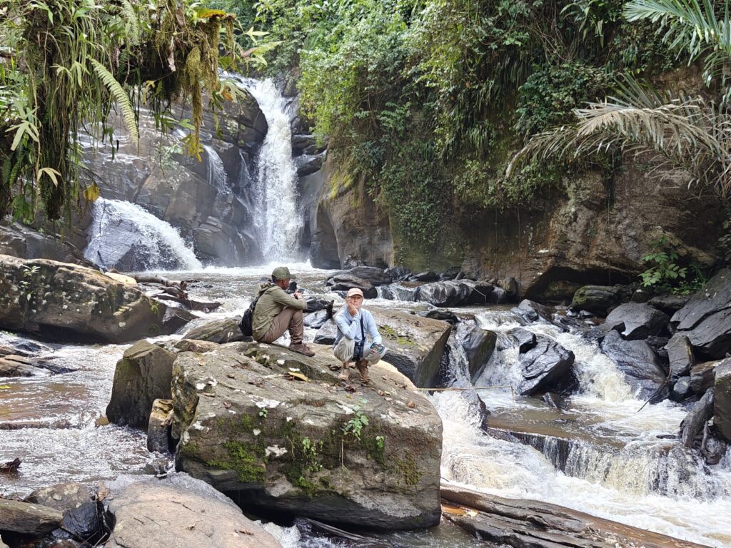
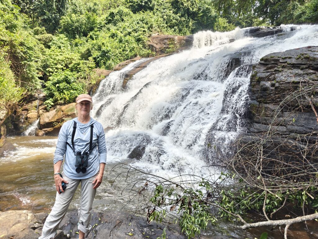
On our second full day we did a 7 mile trek through Shagayu National Forest Reserve, which is a partially protected montain cloud forest. Part of the Forest is industrial forestry; i.e., plantation forestry. The trek started out as a bird walk, but we quickly realized that not only did our guide not know the birds very well but that the vegetation was so dense that we couldn’t see the birds that were there, so we transitioned into what turned out to be largely an ethnobotony trek as our guide was extremely knowledgeable about the various human uses of many of the forest plants. Most of the trail was a wild and steep footpath that was created by local women from the adjacent villages accessing the forest for firewood and medical plants. Along the way we visited a beautiful waterfall that is in the video below and saw the striking black and white colobus monkeys:
Shagayu National Forest Reserve
Along the trail we also encountered a couple of tradional ritual sites that were quite intriguing. Apparently, many of the locals still believe in the spirit world and go to these sites to perform rituals to please the spirits. The ritual can involve cooking and leaving food for the spirits to eat and leaving money for them to spend (?????). These sites are also used by the “healers” to perform a bit of “black magic”; e.g., to bring people luck in the coming days. In fact, we met a party on the trail on the way to one of these sites, including the healer and a man and woman with two chickens that were going to be sacrificed, presumably to bring this supposedly already very rich man (according to our guied) more luck. Here’s a photo of one of these sites:
A black magic ritual site in Shagayu Forest
Here’s a composite video of our visit to MamboViewPoint Lodge and surroundings in the western Usambara Mountains:
OK, we are leaving the mountains and heading back to the coast to visit Saadani National Park, and Nancy’s last stop before Dar es Salaam. See you there!
First, blog business update: OK, I am totally mystified by the MailPoet App on my Blog that sometimes sends me an email notification when someone comments, but sometimes doesn’t, and, moreover, when I reply to the email sometimes it goes to the person submitting the comment and other times it goes to me. Go figure? Software is supposed to be objective and consistent, right? But I sometimes I think software has moods and opinions. Anyways, I have a new tatic that should allow me to reply to you directly via email, so I shouldn’t have to reply via the comment section in the post and you shouldn’t have to go to the comments section in the blog to find my reply.
After leaving the village of Shimoni on the southern-most coast of Kenya, we crossed the border into Tanzania (pretty painless, except it took 1.5 hours due to all the paperwork required at this particular border crossing), and headed to our first destination, the Amani Nature Reserve, located in the Eastern Usambara Mountains in the far northeast of the country.
The Amani Nature Reserve, encompassing 32 square miles, was established in 1997 in order to preserve the unique flora and fauna of the Eastern Usambara Mountains. These mountains form the northern portion of what has been termed the Eastern Arc Mountains located in eastern Tanzania and southeastern Kenya. The Arc is an archipelago-like string of forest-capped mountains heavily influenced by the Indian Ocean climate, so they receive a lot of rainfall. The result is highly productive and diverse forest. The trees here for a dense canopy that rises 200 plus feet off the forest floor. Unfortunately, most of the mountains within the Arc have been deforested by local communities, so there are very few remnant montain forests left within the Arc. Udzungwa Mountains National Park (which we visited with Phil, Mary, Bill and Rick two years ago on our Tanzania trip) and Amani Reserve are two of the largest remnant montain forests within the Arc.
The East and West Usambara Mountains, home to the native Shambaa people, are considered a biodiversity hotspot and is listed as one of the top 12 bird-watching locations in the world by Bird Life International, and the Reserve is recognized as a Man and Biosphere Reserve by UNESCO. The Reserve’s rich biodiversity is partly because it includes an exceptionally wide range of ecosystems, including tall sub-montane evergreen cloud forests and deciduous to semi-deciduous lowland forests and numerous endemic species, including a dozen species of African violets, a dozen or so species of chameleons and numerous other species. Amani is perhaps most renowned for its bird diversity and number of endemics that draws hard-core birders, mostly from the states and U.K. We learned that eco-tourism has become the Reserve’s sole means of generating revenue and almost all of that is from international birders. It’s worth highlighting that birders do indeed provide a lot of support for international conservation, at least indirectly, through their efforts to see bird species. I picked up an additional 22 new bird species (see list below).
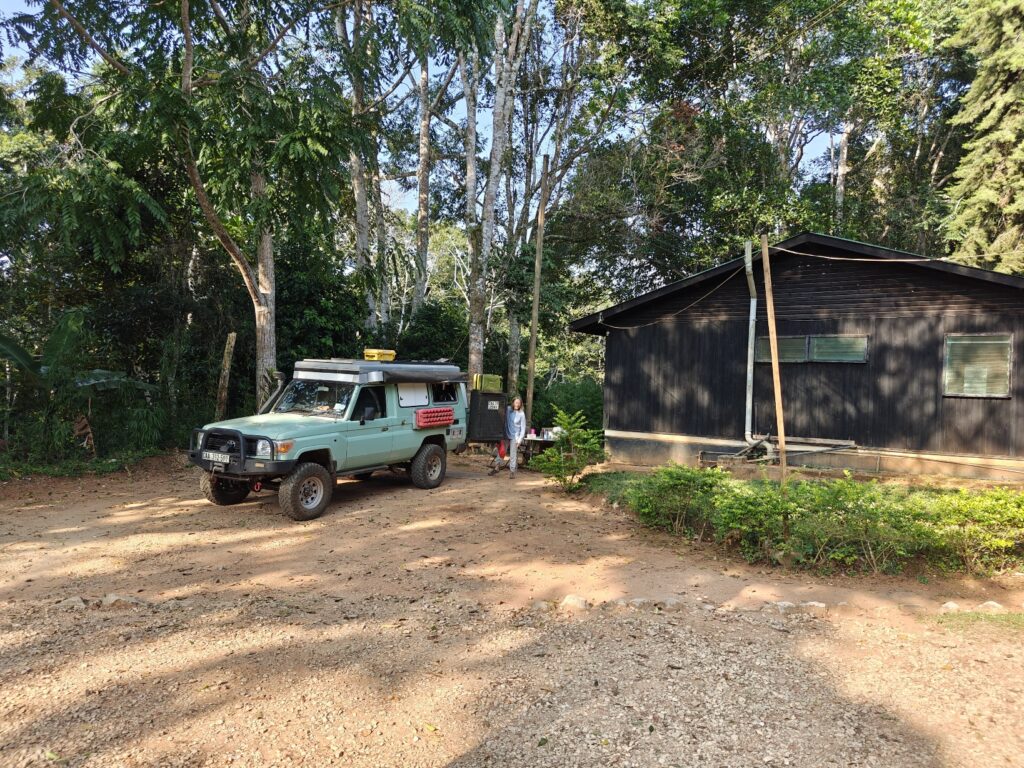
We camped at Amani Forest Camp next to the headquarters of the Reserve. Nothing spectacular about the campsite to note. For the first night we simply parked the Green Dragon on a dirt patch next to the cottages since there were no guests in the cottages and the “campground” was occupied by a group of students from the UK. In fact, it was quite noisy and busy all day and evening with people and motorcycles streaming by making noise. Oh, and let’s not forgot the incredibly irritating muslim prayers broadcast over loud speakers at pretty much all hours, including late into the evening and starting up again at 4:00 am. Here’s our first nights not-so-great camp site:
Our first night campsite at Amani Nature Reserve
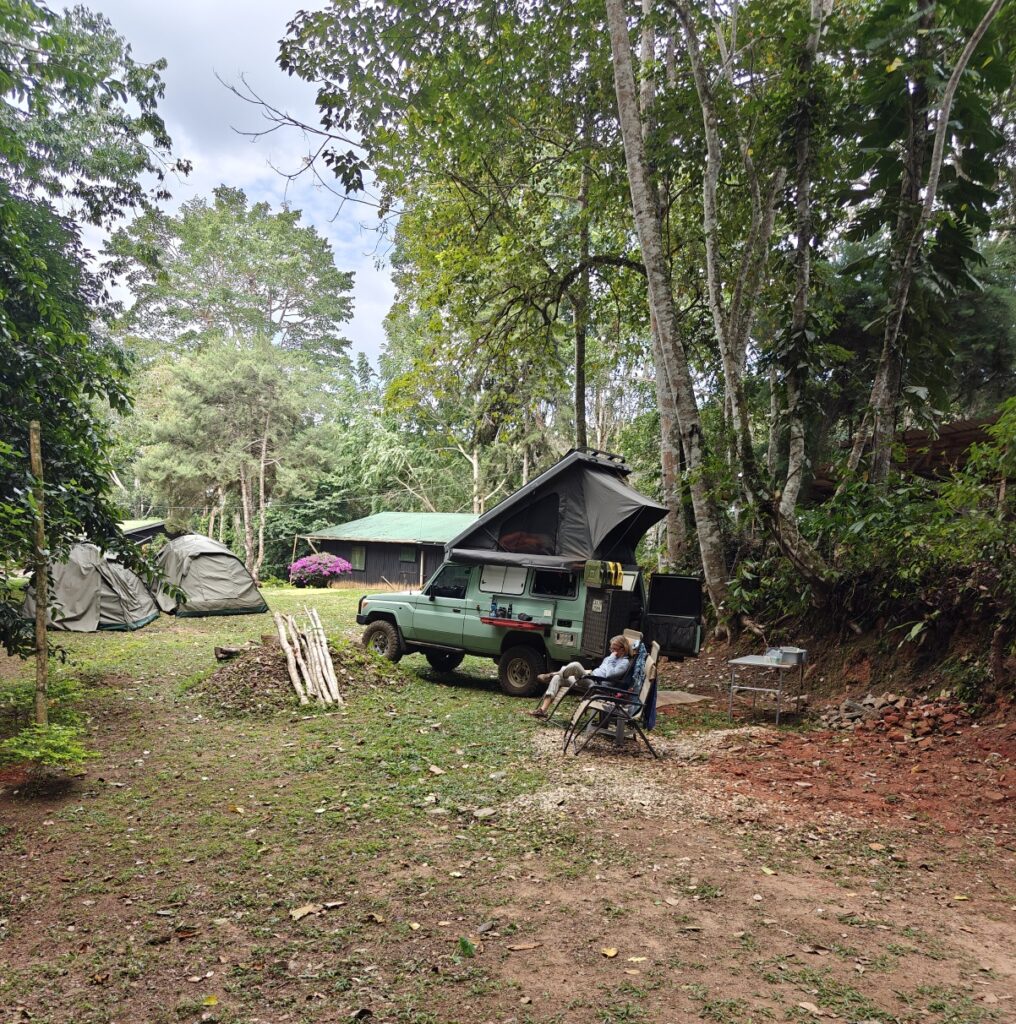
Fortunately, the school group left the following morning and we moved to a grassy patch on the other side of the cottages away from the road; also not a great location, but a bit less noisy. Here’s our new site:
Our second night campsite at Amani Nature Reserve
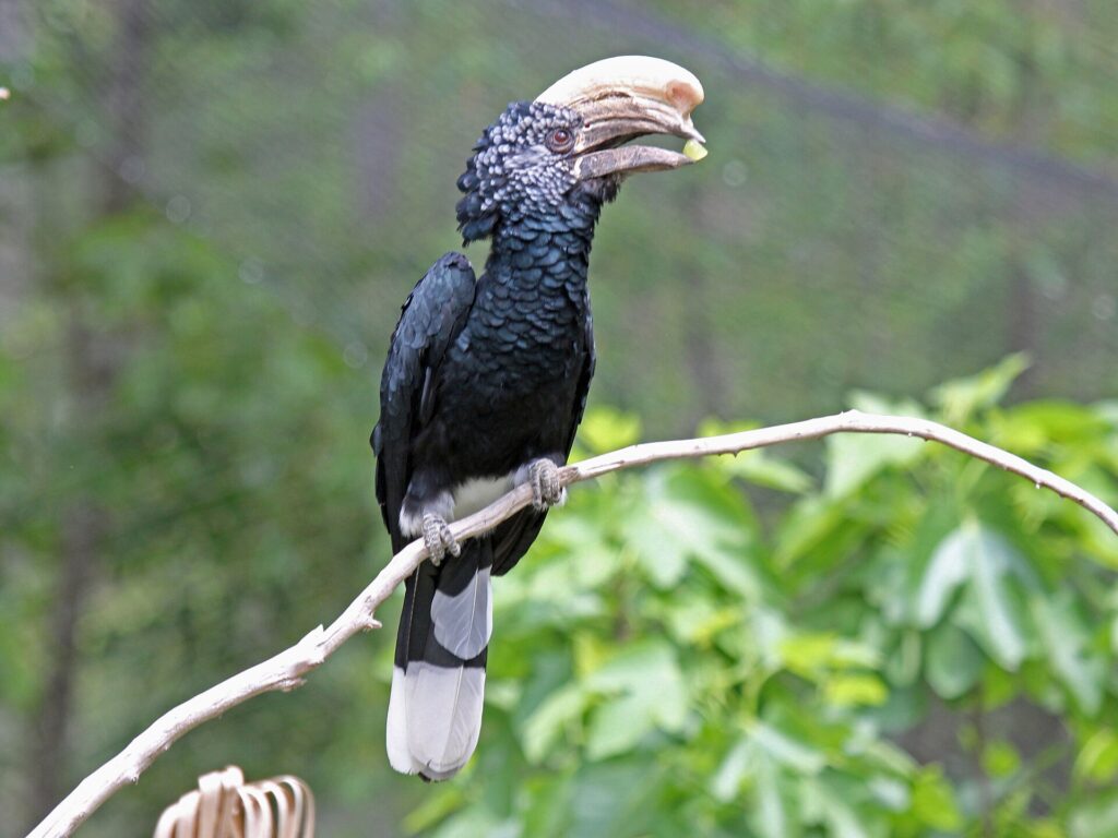
However, we didn’t go there for a great campsite – although that is always very welcome – but instead went to the mountains for a change in environments, having been in grassland and bush savannah and hot and humid coastal tropical lowlands for the past month, to stretch our legs on the many trails, and see some new wildlife species, as there were many new ones to see. One of the really cool new species we saw was the raven-sized Silvery-Cheeked Hornbill. This bird was all around our campsite and all over the forest everywhere we hiked, flying this way and that in the canopy, making a ruckus, but never allowing me to get a picture worth showing, so I am going to show you this picture from the internet:
Silvery-cheeked hornbill
On our first full day, in the morning we hiked to a couple of different waterfalls (with a guide which was required) and along the way stopped at a tea farm and a local (i.e., small-scale) spice farm. Here are a few photos:
On the way to one of the waterfalls in Amani Nature ReserveLocal Saamba kids coming back from schoolOne of the waterfalls in Amani Nature Reserve
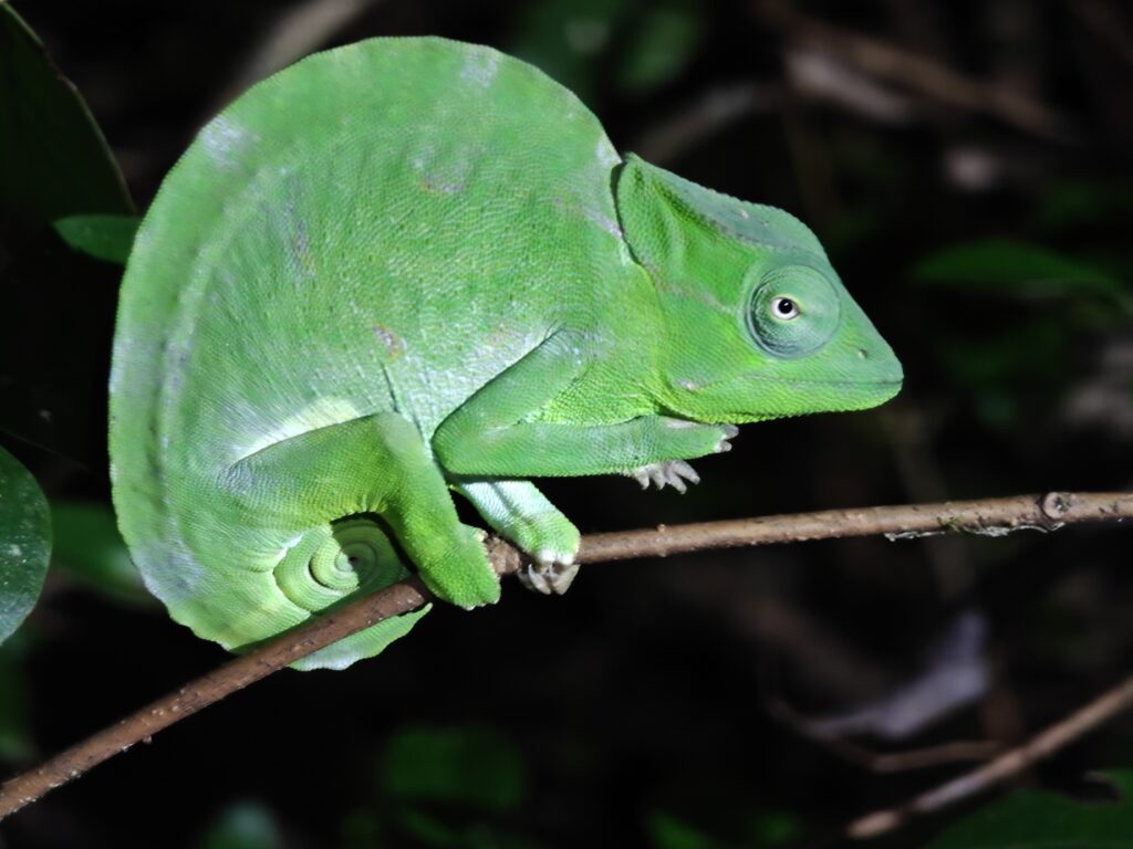
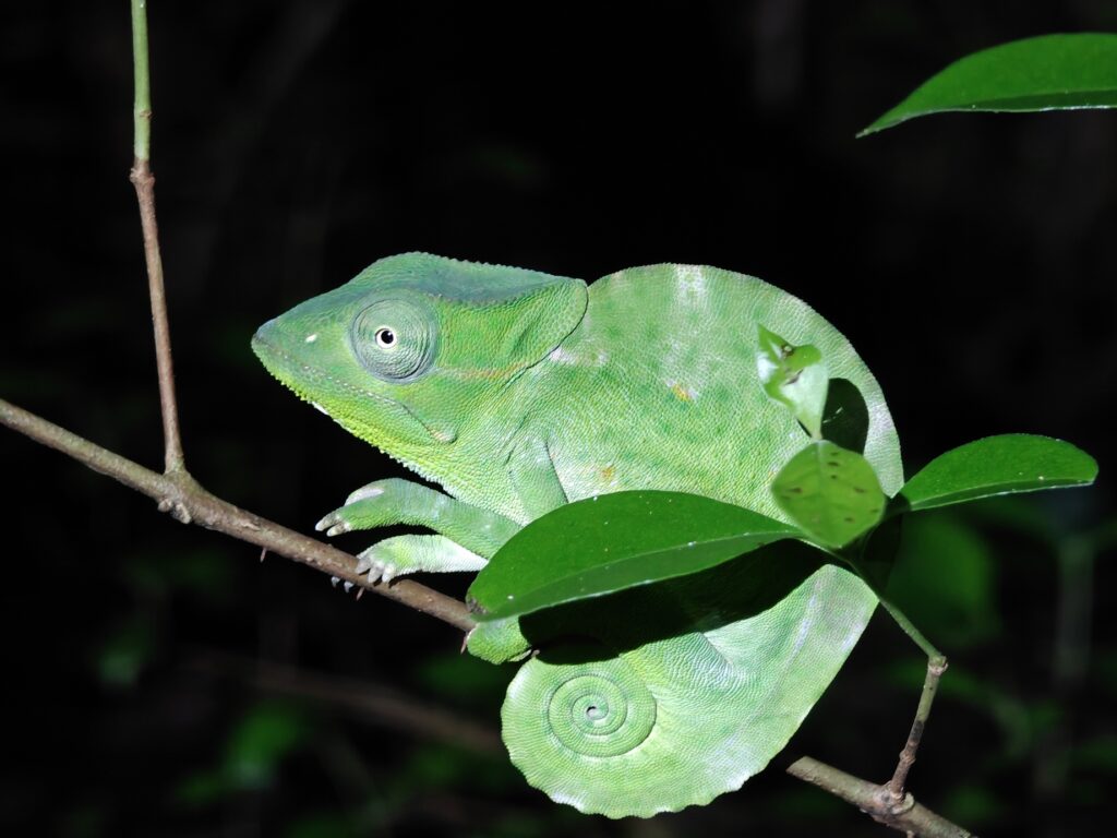
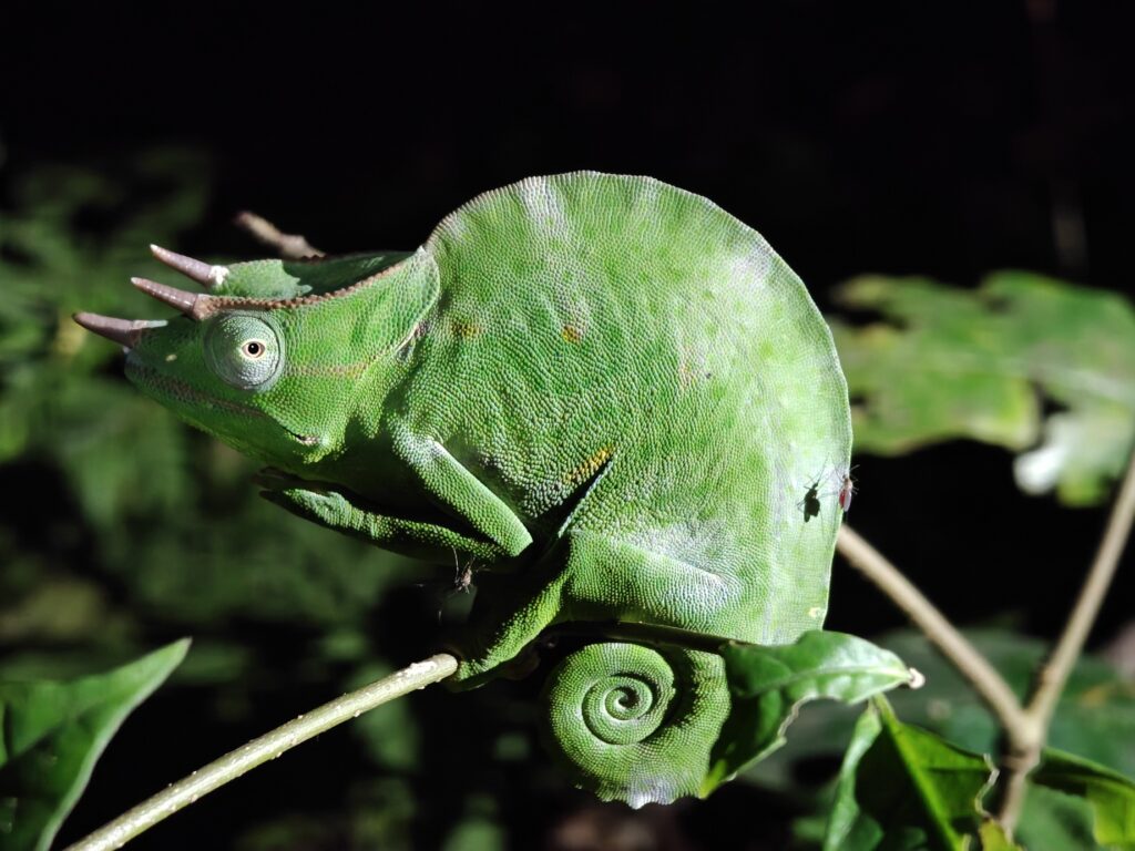
In the evening, we hiked up to a viewpoint of the mountains for sunset and then walked back in the dark. The highlight of the night hike back to camp was spotting three different species of chameleons (and lots of them). Note, I didn’t spot any of these; the guide somehowe did, but it completely baffled me how (Nancy was much better at seeing them once the guide pointed them out):
Sunset in the eastern Usambara MountainsTwo-horned chameleon (female)Two-horned chameleon (female)Three-horned chameleon (male)Pygmy chameleonPygmy chameleon (sleeping)
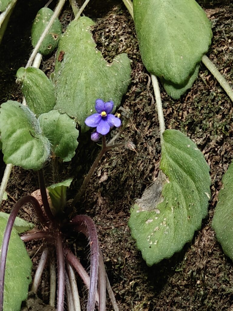
On our second full day, we went birding with local guide in the morning and went looking for African violets (flowers) in the evening. Here are a few photos:
Local Saamba woman we met and bought some bananas fromJust a beautiful flowering plantAfrican violet
And for the action lovers, here’s a composite video of our visit to Amani Nature Reserve that includes a footage of our drive, but most of the footage is of our hikes to the waterfalls, the tea farm, the small spice farm and to see African violets, with a little soccer thrown in for good measure, but no wildlife in this one:
First, blog business. I mentioned at the beginning of this year’s blog that I would respond to comments via email directly to the person commenting. However, I realized just recently that my replies via email are not going to that person but instead have been going back to me without notice – argh! So, that means that many if not all of my replies have gone unnoticed. Sorry about that. I think I am going to have to reply to comments in the blog itself, which means to see my reply you will have to go to that post again and see the comments and replies at the bottom. Sorry, best I can do for now. In most cases, my reply isn’t that informative since no questions were asked of me, so there is probably no need to search for it. However, if you are asking questions about something in my post, then your answer will be found in the replies to comments section.
Next, a few followers have asked “what happened to my hat after that monkey took it of my head” as the video cuts out rather abruptly. Well, I posted a short clip of the scene that Caitlin took, but we have a longer and more complete clip of that scene where we sing happy birthday to Skylar (July 5th birthday; she’s now 4 years old) which we didn’t think the larger community would be interested in, so am going to include that in the composite video below for this post.
OK, back to our travels. After returning to Mombassa from Zanzibar, we recovered the Green Dragon and exited the city as quickly as possible – no more one-night stands in the city for us. Our return flight from Zanzibar was pushed back by 5 hours so we didn’t arrive in Mombasa until early evening. Our original plan was to head south down the coast to the coastal town of Shimoni as a base for exploring the Kisite Marine National Park offshore, but the darkness incentivized us to find place somewhere in between (note, I try to avoid driving after dark at all costs because of the crazy unmarked speed bumps and erratically wondering livestock). So, what do I do when I am looking for an off-the-beaten path, and largely unadvertised, camping spot? I turn to the iOverlander app and see what’s nearby. There were several beachside campgrounds listed, so we took the closest one near the village of Tiwi, which probably doesn’t even show up on most maps. After driving down some barely used tracks, we ended up at the Twiga Lodge and Campground. And, as is often the case with these off-the-beaten path places, it was an absolutely beautiful setting right on the palm tree-lined beach, as shown here (but also see the video):
Our beachside campsite at Twiga Lodge and CampgroundSunrise from our beachside campsite at Twiga Lodge and CampgroundOur beachsite campsite view at Twiga Lodge and CampgroundOur beachside campsite at Twiga Lodge and Campground
With a little sadness, we left our beautiful beachside campsite at Twiga and headed further south to our original destination of Shimoni.
We stayed at the National Park campground located just outside the village of Shimoni on the mainland adjacent to Wasini Island and Kisite-Mpunguti Marine National Park. The campground was pretty basic. It had some really nice shade, an enclosed cooking area, and a water tap. The ablutions left a lot to be desired though. However, we were a stones throw away from the beach, even though we didn’ really have a view, and had the place to ourselves, which is always worthy compensation for below-standard facilities. Here’s our campsite:
oplus_3145728
We took a day trip to the Marine National Park for snorkeling and then lunch on Wasini Island before returning to Shimoni. The snorkling was spectacular: healthy coral reef with an incredible diversity of corals, dozens of different fish and mollusk species, and super clear water. Sorry doodlebug, if your reading this, but this was an amazing snorkle and you would have gone nuts photographing the colorful reef and fish in the super clear waters. Next time? We took a small motor boat out to the reef, passing the inhabited Wasini Island and then a couple of uninhabited islands within the Marine Park before getting out to Kasini Island for snorkling. Here are a few shots, but see the video for action footage of the boat ride and our brief walk on the sand bar of Kisite Island:
Ali1 and Ali2, our boat captain/guideEn route to Kisite-Mpunguti Marine National ParkKisite-Mpunguti Marine National ParkKisite IslandKisite Island sandbar with Roseate and Lesser Crested TernsLunch on Wasini Island
Sean and Derek, in case you are watching, here’s a photo I thought you might appreciate, just in case you were thinking about a career in the Kenyan coast guard:
Kenyan coast guard
Here’s a composite video of our night camping beachside at Twiga Lodge and Campround and our boat ride to and from Kisite Island for snorkling in Kisite-Mpunguti Marine National Park:
After our one-night stand in Mombasa, Nancy and I took a short flight to Zanzibar to meet back up with Caitlin. We left the Green Dragon in the “safe and secure” hands of the Mombasa International Airport security!?
The main island of Zanzibar Tanzania
Zanzibar is an insular semi-autonomous region (actually, some 50 or so islands, but only a few are large enough to be inhabited) which united with Tanganyika in 1964 to form the United Republic of Tanzania. It is an archipelago in the Indian Ocean, 16–31 miles off the coast of the African mainland, and consists of many small islands and two large ones: Unguja (the main island, referred to informally as Zanzibar) and Pemba Island. The capital is Zanzibar City, located on the island of Unguja, and its historic center, Stone Town, where we stayed, is a World Heritage Site.
Zanzibar is a major producer of spices, including some of my favorites: clove, nutmeg, cinnamon and black pepper. Indeed, the Zanzibar Archipelago, together with Tanzania’s Mafia Island, are sometimes referred to locally as the “Spice Islands”. We hired a guide to take us on a tour of historic Stone Town and we purchased some fresh spices (cinnamon, vanilla, paprika and more) from one of the local shops. Zanzibar is also a major producer of raffia, which is a natural fiber that comes from the leaves of the Raffia palm tree used in crafts, fashion, and home decor due to its versatility and durability. Tourism in Zanzibar is a more recent activity and has skyrocketed over the past several decades. Tourists, like us, come to Zanzibar not only to explore the island’s culture and history, but also to relax and play on the many beaches. We are here, in part, to enjoy snorkling in the near-shore waters. Caitlin also took advantage of her two days alone prior to our arrival to go scuba diving off one of the nearby islands.
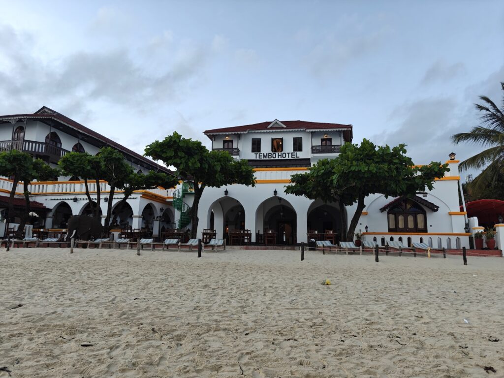
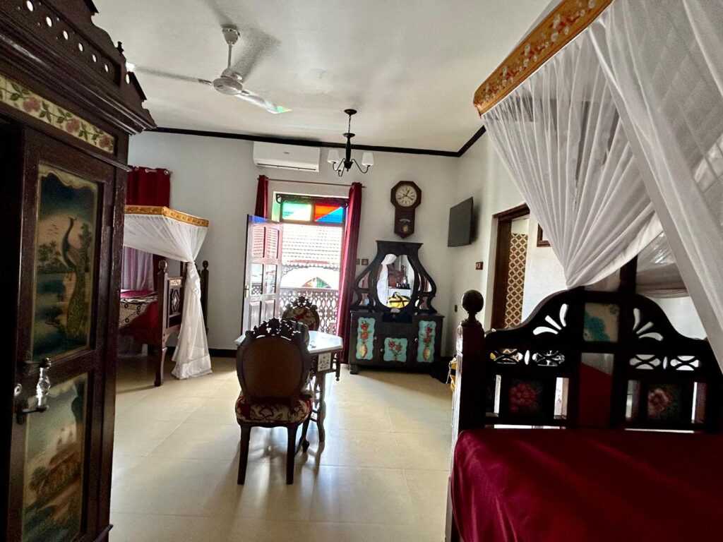
We stayed at the beachside Tembo Hotel, which was an historic building (1883) and it had every bit the feel of one too. We had a single room with 3 beds and large bathroom overlooking a pool and a partial view of the beach and ocean. The hotel opened right onto the beach which provided quick access to the beach and very nice beachside tables for meals. We had several sunset dinners next to the beach. Here are a few shots:
The Tembo HotelOur Tembo Hotel from the beachOur Tembo Hotel roomView from our Tembo Hotel room balconySunset dinner in Stone TownBreakfast from our hotel beach patioSunset dinner at the Fish Market restaurantJust another beautiful sunset from our beachside dining
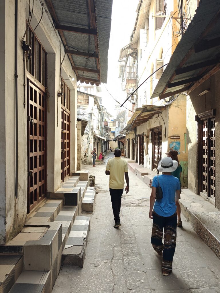
We walked the maize of narrow “streets” (motorcycles and pedestrians only) of Stone Town with a guide to learn some of the history. The town is literally a complex maize of narrow streets and alleys, and it is almost impossible to navigate without getting lost. Here’s what many of these streets and alleys look like before the daily hustle and bustle began:
Walking Stone Town’s streeets with a guideWalking the streets of Stone Town with a guide
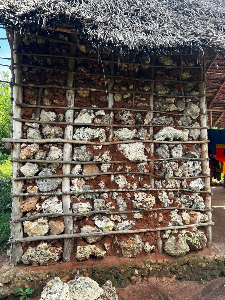
Most of the tour focused on the architectural history owing to the Arab and Indian cultures that largely built the city, but what I found interesting was that all of the stone buildings were built from coral mined from the nearby coral reefs, which were cut into blocks and mortared together along with a smoothed surface. Given the number and size of the stone buildings here, the construction of this town must have decimated the coral reefs (see the video below for a snippet showing the coral block construction of an historic Omani fort). See the video for footage of an old Omani Arab fort in Stone Town built from coral like the rest of the buildings, but here’s shot of the coral block construction used by locals in a rural farm setting:
Coral mud and stick construction for local house
Zanzibar has a rather rich and varied history, and much of it nothing to be proud of. Beginning in 1503, the Portuguese were the first non-native people to colonize the islands and oppress the native bantu people. Portuguese possessed the islands for nearly two centuries. The Portuguese mostly treated Zanzibar as a trade depot and left the local chiefs to rule the people. Eventually, however, after a century and a half of more or less peaceful rule, things changed and the Portuguese exerted a more powerful control over the islands. By the end of the 17th century, the local people had enough of the Portuguese and invited the Arab muslims from Oman to rule the islands, which they did for the better part of two centuries, when the British and Germans started to take over control of the region. These two European powers struggled to dominate the islands until eventually the British won out and it became a Brittish protectorate in 1890, although it remained a sovereign state under the rule of the Arab Sultans, until the British rule ended in 1963 and Zanzibar briefly became an independent nation until it formally merged with the mainland Tanganyika in 1964 to become the Republic of Tanzania.
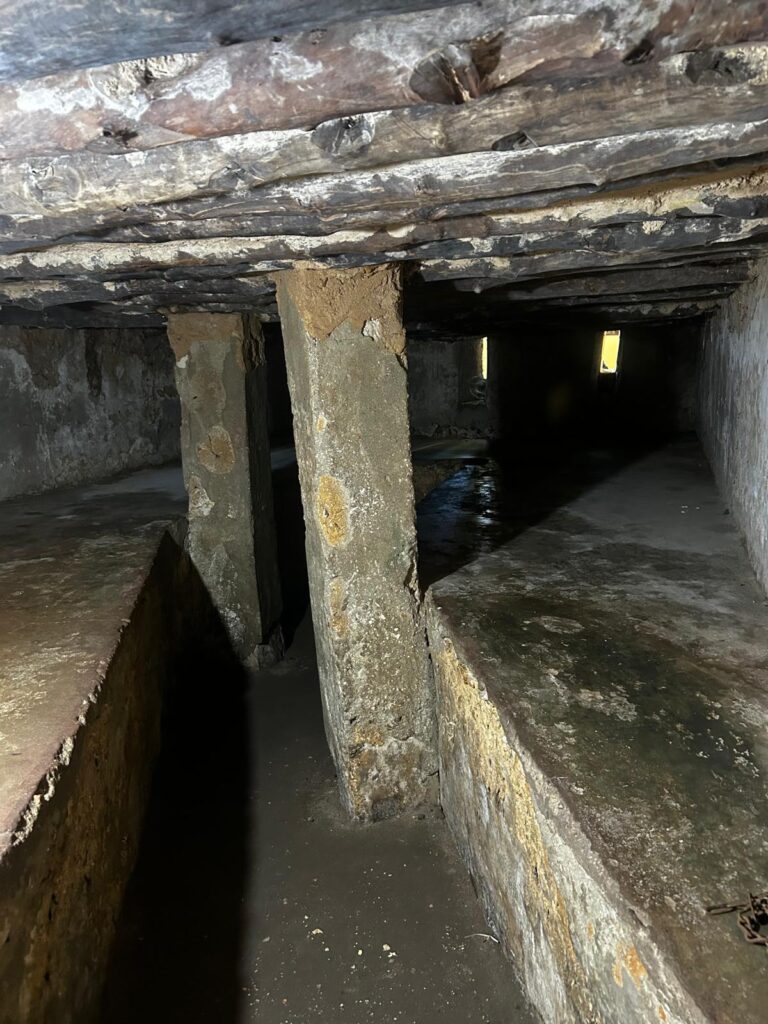
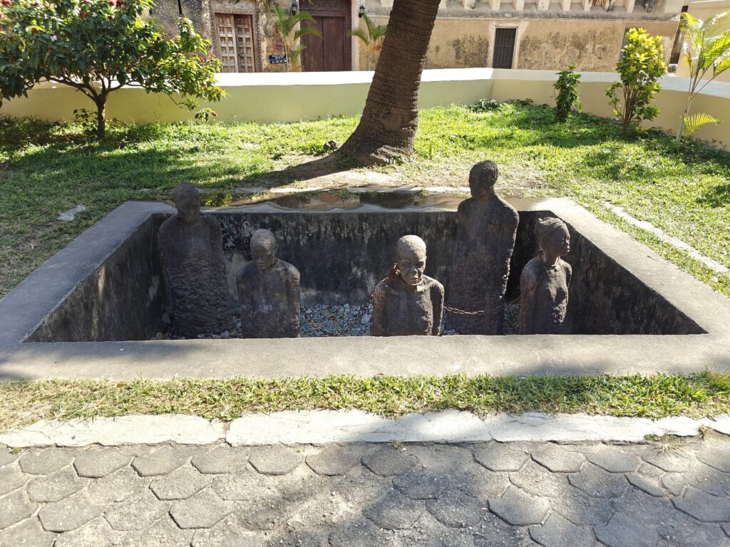
The dark history of Zanzibar under the Arab Omani rule was the trade in slaves from the mainland. Zanzibar was a major center for capturing and enslaving native black Africans from the mainland for export to the Middle East. Zanzibar was the center of the East African slave trade for two centuries or more, and hundreds of thousands of slaves were marketed here. We visited the site of one of these slave markets in Stone Town and saw the below-ground holding cells where the slaves were kept before sale, and where many died. Here’s a picture of a memorial to the slaves and the slave chamber itself:
Slave chamber in Stone TownMemorial to slave trade in Stone Town
On our second full day we did a snorkling trip on the far side of the island; specifically on coral reefs surrounding a small island named Mnemba owned by Mr. Bill Gates. The trip gave us a chance to see the rural countryside of Zanzibar (i.e., where the locals live and work), which was nice, and the water for snorkling was relatively clear and warm enough for a couple one hour snorkles on different reefs, and an opportunity to walk on some white sandy beach. Here are some photos:
Bill Gates owns this island with a resort and we snorkled on the nearby reefsMe snorkling while Caitlin and Nancy warmed up between snorklesNancy and Caitlin the boat ride to the reefWalkking the white sandy beaches of Zanzibar
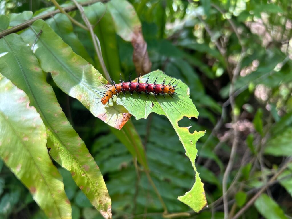
On our third full day we took a guided walk in Jozani-Chwaka National Park, Zanzibar’s one and only national park and a UNESCO Biosphere Preserve. It’s a rather small Park at 19 square miles surrounded by extensive developed land, so it acts as an “island” for many species. You are required to have a guide in the Park and we had a great one, a young man named Thabit who was one of the few guides trained to identify birds. He rarely gets visitors interested in birds as well as other wildlife so he was excited to go birding with us. Almost all visitors come to see the Zanzibar red colobus and Blue (or Sykes) monkeys. We walked the buffer zone of the Park, which is lived on and farmed by locals who get compensated for any animal damage such as lost crops, walked the mahogany forest and the coastal mangrove forest in search of all things animal. We saw lots of new mammal and bird species. A highlight was watching a black and rufous elephant shrew which is 9-12 inches long not counting the tail, essentially the size of a Norway rat, but way more beautiful and interesting. There is a great piece of footage in the composite video below. Another highlight was the close encounters with both species of monkeys, also with some good footage in the video. Here are some photos of our visit, but see the video for more action and narration:
Birding in the farmed buffer zone of Jozani National ParkExploring the trails in Jozani National ParkExploring the mohogany forest of Jozani National ParkExploring the mangrove forest/swamp of Jozani National ParkZanzibar red colobus monkeyBlue (Sykes) monkeyJust a really pretty caterpillar
The composite video below has footage of our hotel accommodations plus all of our outings, including our historical walk of Stone Town, our snorkling trip and our visit to Jozani National Park. Be sure to look out for “Einstein” the red colobus – you will know why we dubbed him Einstein when you see him:
Nancy and I left Tsavo East NP and drove a few hours to the port city of Mombasa on the coast. Mombasa is the second largest city in Kenya and a major port for the import and export of international trade goods. We only went to Mombasa to catch a short flight over to Zanzibar to meet back up with Caitlin.
The drive to Mombasa on the Nairobi-Mombasa highway was more or less like driving through hell. Picture a TWO-lane (yes, I said two lane) highway packed with an endless line of frieght trucks moving in both directions, with a few passenger vehicles interspersed for good measure. Keep in mind this is THE major highway for the transport of all goods from the port of Mombasa to Nairobi and points beyond. Yes, they have a rail line, as you would expect, but it doesn’t appear to be used to move frieght, only passengers – go figure? Now picture some trucks barely moving at, say, 10 km/hour (barely a crawl), and others moving at, say, 100 km/hour (fast moving). Now picture matatus (mini passenger buses) going 140 km/hour (speeding) with no road etiquette, zipping in and out, passing at all times regardless of the visibility ahead with no consideration for anyones safety – apparently this includes their own passengers who have paid rock bottom fees for the cheapest and quickest way to get from point A to B. Most of these matatus look like they have been in multiple accidents. Basically, you are going along at, say, 80 km/hour and then a matatu comes flying pass you out of no where even though you are constantly checking your rear-view mirror, then you have to come almost to a screeching halt because the truck ahead of you is in first gear going up a slight incline. Then, you think about overtaking the truck ahead of you, and just when you start to pull into the oncoming lane a huge semi frieght truck comes barreling past you from behind without the slightest care for your safety, ignoring your turn signal indicating that you were about to overtake the vehicle in front. You swerve back into your own lane just in the nick of time as the truck nearly takes off your side-view mirror. Eventually you risk another attempt to overtake the sluggish truck ahead because you can’t fathom staying in 1st gear for the next 180 km. You gun it, overtake the truck, and swerve back into your lane just before an oncoming truck almost smashes head-on into you. You speed up, slam on the breaks, speed up again, come almost to a stop because the rumble tracks in the highway ahead cause the trucks ahead to come almost to a complete stop in order to roll over them without losing their load, then you speed up and pass 4 trucks in a row, swerve back into your lane just in time, downshift to 2nd gear to keep from running into the donkey-pulling cart ahead, start to overtake the truck ahead but a frieght truck or matatu comes zipping past you from behind without notice and you frantically swerve back into your lane, then you pull out again and hit the accelerator to pass the line of trucks ahead and just as you get beyond them an turn back into your own lane you quickly downshift to avoid hitting the herd of goats and really stupid cows that randomly decide to cross the HIGHWAY at that very second. You swerve in and out of your lane trying to leap ahead of the slow-moving trucks whenever a chance allows, but always ready to brake rapidy for the many unmarked speed bumps, rumble tracks, donkey carts and livestock on this MAJOR HIGHWAY, less you destroy your vehicle. Now imagine playing this cat and mouse game for 180 km and 3 hours of madness. There is NO pleasure in driving the Mombasa highway from hell and Kenya should be ashamed that this is what they have for their major transportation route through the country. I have officially dubbed this highway the worse road to drive in Kenya and probably all of Africa. Please, may I never have to drive this road again.
Eventually, we made it to Mombasa, but due to the chaotic traffic and unclear guidance from the web as to useful shopping centers, we failed to get any of the planned errands completed, except one. After finding a hotel and getting admitted, I braved a trip in a tuk-tuk (i.e., a 3-wheeled hybrid motorcycle-car taxi) to find a hardware store to get a couple of nuts and bolts for the Green Dragon. Braving city traffic in a tuk-tuk is a hair-raising experience (oh ya, I don’t have any hair left to raise, which is probably a good thing). Not only did I loose a few of my remaining hairs, but I probably lost a year of my life breathing in all the exhaust fumes from the thousands of tuk-tuks, motorcycles and other vehicles that do not have catalytic converters to say the least. After visiting 4 so-called hardware stores – which is an experience itself – I actually found one that had what I needed. This hardware store was just like the other 20 or so hardware stores I passed on the street and the 4 I visited, each of which was a store of about 8 feet wide by 20 feet deep and stacked with unmarked boxes of miscellaneous hardware supplies. After presenting the bolt I needed copies of, the owern (usually of Indian decent) would send their servant helper (always a young black African) into the shelving stacks behind the counter to riffle through unmarked boxes of all shapes, sizes and colors, with no obvious organization to the stock, at least to my eyes. At my 5th store I was truly shocked when the helper came back from the stacks with just the bolt I needed – incredible. I had given up any chance of finding what I needed after the 3rd shop, but persisted nonetheless. You have to remember that you can’t get anything done quickly in Africa, but often if you persist and go to enough places you can eventually get most things done. TIA and it requires a great deal of patience.
OK, I don’t have much else to say about Mombasa, as we weren’t here to enjoy whatever pleasures this city has to offer. We just needed a bed and shower before catching our flight to Zanzibar, where Caitlin awaited.
After leaving Tsavo West National Park, we headed east to Tsavo East National Park for a couple of nights en route to Mombasa where Nancy and I will catch a flight to Zanzibar.
On to Tsavo East National Park
Tsavo East National Park was established in 1948 along with Tsavo West, and it is the largest Park in Kenya, covering an area of 5,308 square miles. The Park hosts the 180-mile long Yatta Plateau, said to be the longest lava flow in the world. Tsavo East is generally flat, with dry plains across which the Athi, Tsavo and Galana (the largest) Rivers flow. Most of the park consists of semi-arid grasslands and scrub savannah and vast areas, and I mean vast, are remote and largely inaccessible. Semi-desert wilderness at its finest I am told (since I can’t say that I experienced it). Here are a few photos of the landscape we visited:
Tsavo East landscape (looks a lot like the southwestern US, except those aren’t junipers)Tsavo East landscapeTsavo East landscape (and the red soils)
The Park is perhaps most famous for the red elephants, which appear red because of the red-colored soil they bath in. Unbelievably, even though we saw plenty of red-colored elephants, I (we) failed to get a picture. We photographed some gray-colored elephants, but not the red. That was an oversight, sorry. However, I did manage to get a shot of Nancy next to a rather large red-colored termite mound that will give you a picture of the very red soil in much of the Park:
Nancy next to one of the many red termite mounts
For the first night in Tsavo East, we stayed in Lugard Falls public campsite right on the Galana River a couple of kilometers below the falls.
Luggard Falls on the Galana RiverGalana River below Luggard FallsOur exclusive riverside campsite below Luggard Falls on the Galana River
We had hippos and crocs in the river beside us and at night a mid-size cat wondered through camp unseen by us, having left only tracks. We determined it was likely either a serval cat or caracal cat – way cool. I wish I had brought my game camera. Our evening drive wasn’t too productive but it gave Caitlin, Mook and Nancy one last chance to ride atop the Blue Rhino for viewing – Caitlin especially loved the high viewing platform:
Caitlin atop the Blue Rhino in Tsavo East
For our second and last night in Tsavo East, we bid a sad farewell to brother Mark, who headed to the states to reunite with Kirsten for the rest of their holiday, and a “see you soon” to Caitlin, who headed to Nairobi with Mark and then flew to Zanzibar, where we will meet up with her. Nancy and I moved south to Ndolo public campsite, which put us closer to Mombassa and our flight to Zanzibar the following day.
Our campsite was situated in a shady grove of trees close to the seasonal Voi River – now dry – and its floodplain. The campsite had decent ablution facilities, which gave us a chance to shower and clean the built up dirt and grime off our bodies from 3 days in the bush without showers. We had the campground to ourselves, except for the resident camp tenders, until the evening when another party arrived. And, oh ya, we shared the campsite with a troop of very vigilant and daring baboons and their cousins, vervet monkeys. These guys were always on the ready for any opportunity to raid. We defended our site and belongings until the very last minute, when I went around the Green Dragon to get something and a baboon hidden in a nearby tree darted in and stole an almost empty carton of oat milk. No big loss, but I hate to see the trash dragged into the bush. There was a water hole about 100 yards from our campsite, so there was constant elephant traffice to and from the water hole. They all skirted the campsite itself, so no close encounters this time. Apparently 10 lions visited the water hole the previous night, according to the camp tender, but we saw and heard none during our visit. I am sorry but I forgot to take a picture of our campsite.
Our evening drive was along the now dry Voi River floodplain which turned out to be elephant central. We must have seen a few hundred elephants in the floodplain grasslands and woodlands. It seemed at times that every where we looked there were elephants. Water sources this time of year are at a premium and the Park maintains a few water holes (or troughs) along the floodplain, so the elephants don’t stray too far. We saw lots of animals and a few cool birds, which I will share here:
African elephantMaasai giraffeGerenukMartial eagle (I think)Lesser kudu
Leaving the Park we drove through an “Elephant Grid” fence, one of several we have gone through on this trip, but I failed to talk about. Anyways, the elephant grid is a fence designed to keep elephants either in or out of an area. In this case, the fence keeps elephants from leaving the Park and entering the residential area and farms adjacent to the Park. The fence has flexible wires that stick out from the fence thatI guess would poke the elephent and deter them from crashing through the fence itself. For the vehicle crossings at the gates, the fence includes dangling wires that scrape the top of the vehicle and I presume would frighten an elephant and thus deter them from passing. Here’s what it looks like for a vehicle passing under the hanging wire fence:
Elephant grid fence
From the Wildside:
“Dinner for 9 please”“Is that me that stinks?”
Here’s a short video of our Tsavo East National Park visit:
After leaving Amboseli, we headed east a couple hours drive to Tsavo West National Park, located roughly 150 miles southwest of Nairobi.
The park is one of the oldest Parks in Kenya, having been established in 1948. It is the second largest Park in Kenya (after Tsavo East NP, our next stop), covering an area of 3,500 square miles, and is separated from Tsavo East National Park by the major Nairobi-Mombasa highway and railway. The Park was named after the magnificent Tsavo river, which is the main river that drains the park, as shown here:
Tsavo River in Tsavo West National Park
Tsavo West is yet another “classic Africa” Park characterized by a vast savannah ecosystem with open grasslands, scrublands, and Acacia woodlands, belts of riverine riparian vegetation and striking rocky ridges. The park is known as “Land of Lava, Springs, Man-eaters and Magical Sunsets”. Its popularity is based on the man-eating lions that killed hundreds of people during the construction of the Railway line and the highway during the colonial era, which was the real life basis for movies such as “The Ghost and the Darkness”. Indeed, there are cases of lions getting a taste for human flesh and realizing how easy prey we are, but these are exceptions, not the rule, so don’t worry. The Park has a relatively low density of wildlife (although see the photo gallery below for a few photos), so we ended up doing a fair amount of driving without seeing many animals. However, the landscape was so striking that a respite from wildlive viewing was OK. Here are some photos of the striking landsape of Tsavo West:
200-year old lava flow in the ParkBaobab sunset in the ParkTsavo West landscapeTsavo West landscapeTsavo West landscapeTsavo West landscapeTsavo West landscapeTsavo West landscapeTsavo West landscape (and the Blue Rhino)Tsavo West landscape (Rhino Valley)
We planned and paid for two nights camping at the Chyulu public campsite (one of only two in the Park), but we were informed that it was not usable (for unspecified reasons) or advisable due to the abundance of tsetse flies in that area. Fortunately, we had already decided to switch our booking to the Kudu special campsite situated along the Tsavo River, which we learned from blogs was a magical site. However, to our dismay, we were informed that a large party was already booked for the site our first night. Then we were informed that all the other designated special campsites were not accessible at this time because of damage from the wet-season flooding. Dilemma, what to do? We paid $35 USD per person per night for a special campsite, instead of the $20 for the public campsite.
The Park agent at the gate got on the phone and found out that another special site, not advertised, existed and was available. Great, send us there please! After getting directions from the other Park official on the phone, we marked a waypoint in the GPS and headed out. Did I already mention in this blog that most Park officials have absolutely no clue what goes on outside their own very narrow sphere of duties. Well, you guessed it. We got to the specified location after about an hour of driving and there was no sign that a campsite ever existed anywhere within several kilometers. So what to do? We travelled on a bit further to the second public campsite and briefly considered staying there, although there was nothing appealing about the site other than having facilities and water. We talked to the Park warden on the phone and he said that our special campsite and all the others are not open at this time. OK, but what about the expense we paid for a Special campsite? After some discussion, the Warden said our only option was to go to the Kudu campsite, and he assured us that there would be plenty of room for both our party and the other booked party. Great! We headed out and one hour later we arrived at what was indeed a magical site right along the Tsavo River. The only problem was that there was already a very large high-end mobile safari group (probably 10 guests and an equal number of staff) on site and they had it fully occupied. We’re talking huge tents, each with a separate toilet and shower, all strung out along the bank. Not only that, but they didn’t want us to crash their privacy when they had high-paying clients with them. Fortunately, the head man said he had seen a delightful riverside site a few kilometers upriver, but that we may have to maneuver the vehicles a bit to get into it from the road. So, with darkness approaching, we headed up river and found the spot. It involved about 100 yards or so of off-road maneuvering through the brush and trees and over some bumpy ground, but we ended up at a very nice riverside spot for our camp (watch the video if your want to see our winding track into the site). We settled in for the night and enjoyed a riverside campfire, flute music, and gourmet found from our resident chef – Caitlin. Here’s a photo of our site (but see the video for more complete coverage).
Our riverside wild campsite and the doodlebug
On our first full day in Tsavo West, we drove about 30 kilometers to Mzima Springs, where there is some 50 million gallons of crystal-clear water gushing out of parched lava rock that is the Mzima Springs. We took what looked to be the best route from our Kudu campite to the springs, but it went through pretty dense scrubland that was home to abundant tsetse flies. These flies are like horseflies or greenheads on steroids. They are attracted to movement and go after the vehicles and all persons inside with a determination that is actually impressive if I didn’t hate them so much. We had to keep the windows open due to the heat – no air conditioning in the Green Dragon – and so we pitched battle with them for about 30 minutes before getting to some nice tstse-free grassland savannah with buffalo, zebra, oryx and hartebeests, along with a few of the smaller antelope species such a impala and dik dik.
Eventualy, we made it to Mzima Springs. This site is a desert oasis extraordaire. Millions of gallons of crystal clear water gushing out of the ground to form pools and a river on its way to the Tsavo River. Apparently, water infiltrates the volanic Chyulu Mountains about 50-100 kilometers north of the Springs and flows underground through the porous basalt rock, getting filtered along the way, and then emerging in this and several other springs. The big coastal city of Mombasa, hundreds of kilometers away, pipes this spring water all the way to the city to supply a large portion of its potable water. Here’s a few photos of the Springs, but see the video for more action commentary:
Mzima Springs (large pool)
For our last night in Tsavo West we intended to stay in an elevated tent platform overlooking a water hole in the Ngulia Rhino Sanctuary, dedicated to the recovery of the black rhino population. Historically, black rhinos were found in Tsavo at densities higher than anywhere else on the planet. In 1940 there were an estimated 20,000 black rhinos in the Tsavo Conservation Area (Tsavo East and West National Parks). By 1989 there were less than 20 individuals as a result of rampant poaching. Within Tsavo West NP, the Ngulia Rhino Sanctuary was established in 1986 as a fenced stronghold to enable the breeding and recovery of black rhino in Tsavo starting with just nine individuals. Today Sanctuary is 35 square miles and is home to over 120 rhino. An Intensive Protection Zone around the Sanctuary was established in 2008 as an unfenced, highly protected, free-ranging area and 19 founder rhinos were introduced there. This population has grown significantly over time, making the Tsavo rhino recovery one of the most successful and positive conservation stories in recent years.
Instead of the Rhino Sanctuary, we headed downstream to the Kudu special campsite, our intended campsite for our first night. We could have stayed where we were, but the Kudu site was too magical to pass up. This site is high on the bank on a bend in the Tsavo River with great views of the river and the mountains beyond. Here’s a photo of the site (the video also has coverage):
Tsavo River campsite
We didn’t see too much wildlife in Tsavo West, at least not at the densities found elsewhere, but we did manage to encounter some. Here are a few photos:
Elephant (with big Tsavo tusks)Hippo haulout on the Tsavo River just upstream from our campsiteAfrican buffalo herd at water holeWater dikkop on night driveSykes monkeyMaasai giraffe
For you action lovers, here’s my composite video of Tsavo West National Park. Note, much of the footage is of driving through the striking landscape and visiting Mzima Springs, as the wildlife was scarce and hard to video:
After leaving Meru National Park, we headed south back to Nairobi for a couple of nights of R&R&R (the last R is for “resupply”) before heading south to Amboseli National Park:
We left Nairobi on schedule, but sadly without Kirsten who went off to Thailand for two weeks of intensive professional training, and headed south to one of the crown jewels of Kenya, Amboseli National Park which lies about 150 miles from Nairobi. Caitlin and I left in the Green Dragon to pick up a new refrigerator for the Dragon, while Mark and Nancy headed out to Amboseli in Mark’s “Blue Rhino” (his Land Rover Defender). However, we both ran into problems.
Caitlin and I picked up the new frig and realized it wouldn’t fit in the Green Dragon, so we had to return it.
The new frig just doesn’t fit properly, argh!
After much consideration, we decided to go back to Mark’s house and get the old frig and make due with it for this year’s trip. It basically works but you can’t read the control panel anymore so it’s hard to regulate the frig temp or make any changes to the operation of the frig. However, the new frig simply would not fit and there were no other frig’s in Nairobi that would work that wouldn’t take days to purchase (TIA). I decided the best and almost only option was to stay with my old frig. Caitlin and I drove back to Mark’s house which was completely locked up, except for one second story window that was slightly ajar. I found a latter and climbed to the balcony below the window and Caitlin followed.
Breaking in to Mark’s house
We jury rigged the window to stay fully open and I used a fireman’s carry to lift Caitlin backwards, feet first, in through the window while she gently inched her way down the inside face of the window until her foot found footing. The two of us decided we were top-notch burglers and could go in to business! Can’t imagine what the day workers thought that passed us by as we were climbing in through the windows. OK, we got the frig and headed on our way south and all was good again.
Meanwhile, Mark and Nancy ran into troubles of their own. About 1.5 hours out of Nairobi, Mark got singled out by the local “police” for an unknown and unspecified traffic violation (despite the fact that every vehicle was violating every traffic law at the same time in the same place) and the “officer” tried to play Mark for a sucker. After some polite exchanges that were going no where, Mark offered a “bribe”, which is the usual practice, but was immediately threatened with criminal action. The “officer” then boarded his vehicle and had him drive back towards Nairobi, ostensibly to the police station, all the way with Mark pleading for a simple resolution and being threatened by the policeman with major criminal action, stating that Mark would have to go to court to resolve the crime. Eventually, after driving for a hour back towards the city, Mark convinced the “officer” to consider some sort resolution and they returned to an unmarked building, ostensibly a “police” station, near the scene of the infraction. At the very last moment, knowing that Mark only had 8,000 Shillings (~60 USD) on his person, the “cop” relented and took the bribe and sent Mark and Nancy on their way. It sucks to succumb to this form of corruption with the law enforcement community, and many overlanders claim to have persisted and gotten out of the ordeal without paying anything or giving anything, but the headache of playing the cat-and-mouse game can be taxing and overwhelming, and sometimes it just seems worth to pay the bride and move on. The whole ordeal took about an hour. TIA at its best!
Amboseli is designated an UNESCO Park and covers about 150 square miles, but it is part of a much larger transfrontier protected area that encompasses 3,100 square miles. The Park has a truly spectacular setting because it sits at the base of Mount Kilimanjaro, Africa’s highest peak at 19,340 feet, which lies just over the border to the south in Tanzania. Looking out over the savannah with Mount Kilimanjaro looming in the background is simply sublime. Consequently, Amboseli is one of Kenya’s most popular parks, perhaps rivaled only by the Maasai Mara. The name “Amboseli” comes from a Maasai word meaning “salty dust”, and it is one of the best places in Africa to view large herds of elephants up close. Here’s a few shots to wet your appetite for a future visit of your own:
Amboseli and Mount KilimanjaroAmboseli (and elephants)Amboseli (plains zebra and blue wildebeest)Amboseli (and plains zebra)Mount Kilimanjaro and the Doodlebug
Amboseli is in the heart of Maasai country, although people from other tribes have settled here as well because of the successful tourist-driven economy and intensive agriculture along the system of swamps that makes this arid area (average 14-inch precipitation per year) one of the best wildlife-viewing places in Kenya.
The Park abuts several Maasai Conservancies and we met up with the self-proclaimed “chief” of one of the Maasai villages bordering the Park – in actuality he was probably chief only of his family boma consisting of his wives and children and perhaps a sibling or two and their offspring. In fact, later we confirmed with another local Maasai who worked at our lodge (see below) that he was, without question, NOT the local chief . Here is the “chief” with Mark, noting that the chief is not wearing the tradional red garb of the Maasia, but the less common blue:
Mark with the Maasai “chief”
Amboseli is SO popular as a wildlife safari destination that the safari vehicles can outnumber the wildlife 10 to 1 when any of the cats are sighted. It’s probably fair to say that the vast majority of guided visitors are there to see the big cats and elephants, which is probably true of most Parks. The “lesser” wildlife generally get very litte attention, especially the smalller birds. Indeed, we had an unpleasant experience with a lion sighting during our visit. We went on a night drive with a guide and ranger and followed 4 lions on the initial stages of a hunt. It was a memorable experience becuause it was a private viewing of raw wildlife in action (see the video below for footage). The next morning we decided to go to the area where we had observed the lions in hopes of finding them on a kill. Much to our dismay, the safari guides had already found the lions and there were perhaps 30 vehicles at the scene when we arrived first thing in the morning. It was extremely anti-climatic after our intimate night-time observation. We drove past the mad-house without barely a glance over at the lions, desperate to get away from the crazy safari vehicles filled with tourists desperate to see lions at all costs, even if it meant sharing the experience with a 100 strangers. Here’s a shot of the end of the vehicle train stopped to see the lions:
Safari madness
The park protects two large swamps and includes the dried-up Pleistocene Lake Amboseli. The swamps are a central feature of the Park and attract abundant wildlife, especially during the dry season, as you might expect. Apparently, the swamps are supplied with ground water stemming from the nearby Mount Kilimanjaro that infiltrates the ground high up on the slopes and emerges in places on the Plains below. Otherwise, the Park is dominated by extensive grasslands that support herds of grazing animals, including mostly blue wildebeest, plains zebra, Thompson’s and Grant’s gazelles, African buffalo and elephants, along with the occassional hippo when they are out of the water, not to mention numerous bird species (see below). Here a lots of photos of wildlife for you wildlife lovers, and I included some not-so-spectacular photos of several bird species for you birders – yes, I am referring to you Phil and Brenda, and some others:
oplus_1048576Wire-tailed swallowLesser flamingoLesser flamingoSpotted hyenaThompson’s gazelleKori bustardSaddle-billed storkGray crowned craneCollared pratincoleBlue wildebeestSquacco heronLittle bee-eater (sorry not in great focus because of the extreme zoom)Grey-headed kingfisher
We stayed about a 30-minute drive outside the Park in a private camp/lodge called Amboseli Bush Camp. No need for the Green Dragon at this camp, as we took advantage of the platform tents with beds. The camp has a lounge area overlooking a water hole, along with a well-appointed kitchen and a fire pit. The kitchen has an oven, so we took advantage of it and Mark made pizza, not once, but twice during our three-night stay – being on safari doesn’t always mean dirt and pit toilets. And need I say that if Mark had one food to keep in a post-apocalyptic world it would be pizza!. You’ll have to watch the video below if you want to see our accommodations, but here are photos of Caitlin’s gourmet meal of stuffed peppers and Mark’s pizza:
Caitlin’s stuffed peppers on bed of quinoaCaitlin’s stuffed pepper (yellow variety) on bed of quinoaMark’s homemade pizza!
And if that wasn’t enough, Mark surprised us (mostly me, I think, as I believe the girls might have known, but didn’t disclose) with homemade cinnamon rolls for breakfast on our last morning!
Mark’s cinnamon rolls!
For you video lovers, here is a rather long (sorry, too much to see and show) video of our Amboseli National Park visit. It includes our tented camp accommodations, lots of elephant action, some cool bird scenes (for the birders) and even a few night videos of spring hares (a.k.a. kangaroo hares) and lions on the hunt: